


The company partners with the Environmental Defense Fund to help fight climate change, reports Engadget.
Despite the fact that carbon dioxide gets most of the attention when it comes to global warming, other factors cannot be ignored. According to the International Energy Agency, methane is responsible for about 30% of the global temperature increase since the industrial revolution. Around 40% of human-caused methane emissions are captured in the energy sector.
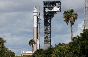
To detect and reduce these emissions, Google has teamed up with the Environmental Defense Fund — the organizations previously collaborated on creating a map of methane leaks in major cities using sensors on Street View cars. The Fund and its partners developed the MethaneSAT satellite, which is planned to be launched on a SpaceX Falcon 9 rocket in early March — it will orbit the Earth 15 times a day at an altitude of over 200 km and focus on measuring methane levels in major oil-producing regions.
Specially designed algorithms have been developed to calculate emissions and their dispersion over time. Artificial intelligence will also be used to accurately identify oil and gas infrastructure — similar to how Google uses this technology to identify sidewalks, street signs, and road names in satellite images for Maps. It is expected that combining the methane map with the oil and gas infrastructure map will provide a clearer picture of emission sources.
The MethaneSAT data sets will be available on Google Earth Engine — a platform for analyzing and processing geographic data, particularly satellite images (which has approximately 100,000 active users monthly).
In previous news, we have already mentioned that Greenland is "melting" faster than previously thought — losing more than 30 million tons of ice per hour. As the ice retreats, the land area with growing vegetation on it has increased by a total of 87.5 thousand square kilometers, more than doubling the area at the start of the study, and threatens even greater greenhouse gas emissions, sea level rise, and landscape instability.
According to The Guardian, currently the number of wetland areas in Greenland producing methane has nearly quadrupled. There are indications that the growth of vegetation is leading to further ice loss.
Previously, methane emissions from glacier melting were also documented by scientists in the Svalbard archipelago.


Comments (0)
There are no comments for now